

Lake Information
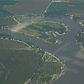
Big Lake is a 646-acre oxbow lake in Holt County, Missouri. It is believed to have formed from the Missouri River sometime before Lewis & Clark visited the area in 1804. It is the largest oxbow lake in the state of Missouri.
Big Lake State Park, a 407-acre state park was established on the lake's northeast side in 1932. The State Park also includes the largest marsh in a state park in Missouri. The remaining two-thirds of the lake shore is occupied by privately owned cabins and residences.
Interesting Facts

Area
Total 2.7 sq mi (6.9 km2)
Land 1.7 sq mi (4.4 km2)
Water 1.0 sq mi (2.5 km2)
Elevation 856ft (261 m)
Density 75.0/sq mi (29.0/km2)
Time zone Central (CST)
FIPS code 29-05495
GNIS feature ID 1669587
Coordinates: 40° 424N 95° 213W
Interesting Facts
Big Lake is a village in Holt County, Missouri, United States.
The village is located on the 646-acre Big Lake which is the largest oxbow lake in Missouri. It is also adjacent to Big Lake State Park which has the largest marsh in a state park in the state of Missouri.
Big Lake is about 10 miles west of Mound City on Route 111 off of Route 118.
Big Lake is only about five miles from the village of Rulo, Nebraska.

Demographics
As of the census of 2012 the total population is 159.
52.20% Male
47.80% Female